December 25th, 2019
The big question...


Yes, those are pleather pants and pull on furry boots...sorry, the pic is a bit blurry as I didn't want to get caught taking the photo.


An hour and about 4 kilometers in, there was a small side track to some waterfalls which I didn’t bother with as I felt I had a good enough view from where I was and I didn’t need to tack on more distance to an already lengthy hike. Shortly after was the first washroom pit stop. The outhouses were strategically placed every 3-4 kilometers and since I tried to maintain hydration by drinking a lot more water than I normally do, I stopped at every one of them (and still had to take one forbidden pee just off the trail!). I liked that in every outhouse was a poster showing the outline of the trail from a sideview with the kilometers along the bottom and elevation on the side. It told you how far along you were, asked questions like “How’s the weather?”, “Is everyone in your group feeling good?”. It also gave the odd stark fact like: “Twice a week a hiker needs to be rescued” or “19% of rescues occur in this section of the trail”.


Interesting rock formation:

 Looking at Blue Lake:


Me and the Mountain of Doom!


Next it was down to another flat area, Red Crater, and then up a small climb to the biggest of the lakes, Blue Lake, which was the halfway point of the trek (distance wise). Looking back from where I’d come it was cool to see the big lava flow that had spewed part way across the crater and then stopped.

This is the view from up near the blue lake. On the right, the darker patch is newer lava.

Yay...just over half way there!


I didn't take a very good picture of it, but this is an impact crater from a volcanic rock from 2012. It's about 10 feet across.


 Nice waterfalls near the end.

Almost there!

I was treated to a lovely sunset to finish the day.

Considered one of the best day hikes in New Zealand and supposedly
worldwide, I figured I’d better hike the Tongariro Alpine Crossing. I had heard of it when I was at Mount Taranaki
back in November and Braden strongly suggested that I do it…okay, sold. It’s one way, 19.4 kilometer trail with 600
meter elevation gain and 950 meter descent on the back half. You need to buy a ticket for a shuttle to
take you to the starting point and pick you up at the end. At the starting point cars are only allowed
to park for four hours so you could only a small section of the trail if you
brought your vehicle. I thought the shuttle
was a bit steep at $40 and really it was two 15-20 minute rides, but you really
had no choice.

I opted to get the first shuttle of the morning, at 6 am, as
the 7 am was already sold out and I thought that 8 was getting a bit late for
the 6-8 hour hike with the forecast stating that rain was possible in the early
afternoon. The bus had already picked up
the other hikers in National Park (a silly name for a little town nearby) and I
was the only one crazy enough to go hiking at 6 am on Christmas Day.

On the bus there were a couple of ladies across from me who
looked to be close to 70 years old. One
had a real grandma look about her and I wondered how far they planned to
go. Then I noticed that the person in
the seat in front of me had pleather, I wasn’t sure if it was her pants but thought
no, must be her backpack. Well I passed
her in the first half hour of the hike and sure enough, this young, I’m guessing
South Korean, woman was wearing pleather pants and pull on furry boots that are
popular in England the last time I was there…hardly the appropriate apparel for
hiking a volcano! To each their own.
Yes, those are pleather pants and pull on furry boots...sorry, the pic is a bit blurry as I didn't want to get caught taking the photo.

The clouds were quite low and for the first hour I was
hiking in and out of them sporadically.
The trail started off easy with a lot of gently climbing boardwalk,
surrounded by volcanic rock with some mosses and grasses making a go of
it. I find it incredible that anything
can eek out a living on such a barren landscape.


At this point, the track started to get steep with some
stairs to help along the way on a section known as the “Devil’s Staircase”…nice. Gaining a few hundred meters the sun was
trying to break through the clouds and occasionally a bit of a view to the valley
below opened up.

Summitting that ridge the trail broke onto the South Crater,
a nice flat section surrounded by rocky walls that were mostly visible but occasionally
fast moving, terrain hugging clouds passed through.


Then it was the final push to the, well not the summit, but
highest point of the trek signified by a pyramid of rocks that hikers had
contributed to, one stone at a time. The wind really picked up as I was getting
close to the top and it was a bit chilly.
Having hit the trail about 6:35, I was at the highest point which is not
quite halfway around 9 am. I thought
this was pretty good, maybe almost too fast, there’s not point in rushing it,
especially since the first return shuttle doesn’t come until 1:30. It’s usually all about the journey, not the
destination. So I intentionally hung out
on the top for at least 20 minutes. I exchanged
taking pictures of couples or groups for a picture of me with my phone. There was a Dutch group with whom I leapfrogged with throughout the hike so I took some photos for them. That’s when I saw the older women from the
bus. Nice, good on you ladies! I actually didn’t see them again…until the
end. They finished the hike faster than
me!

Interesting rock formation:


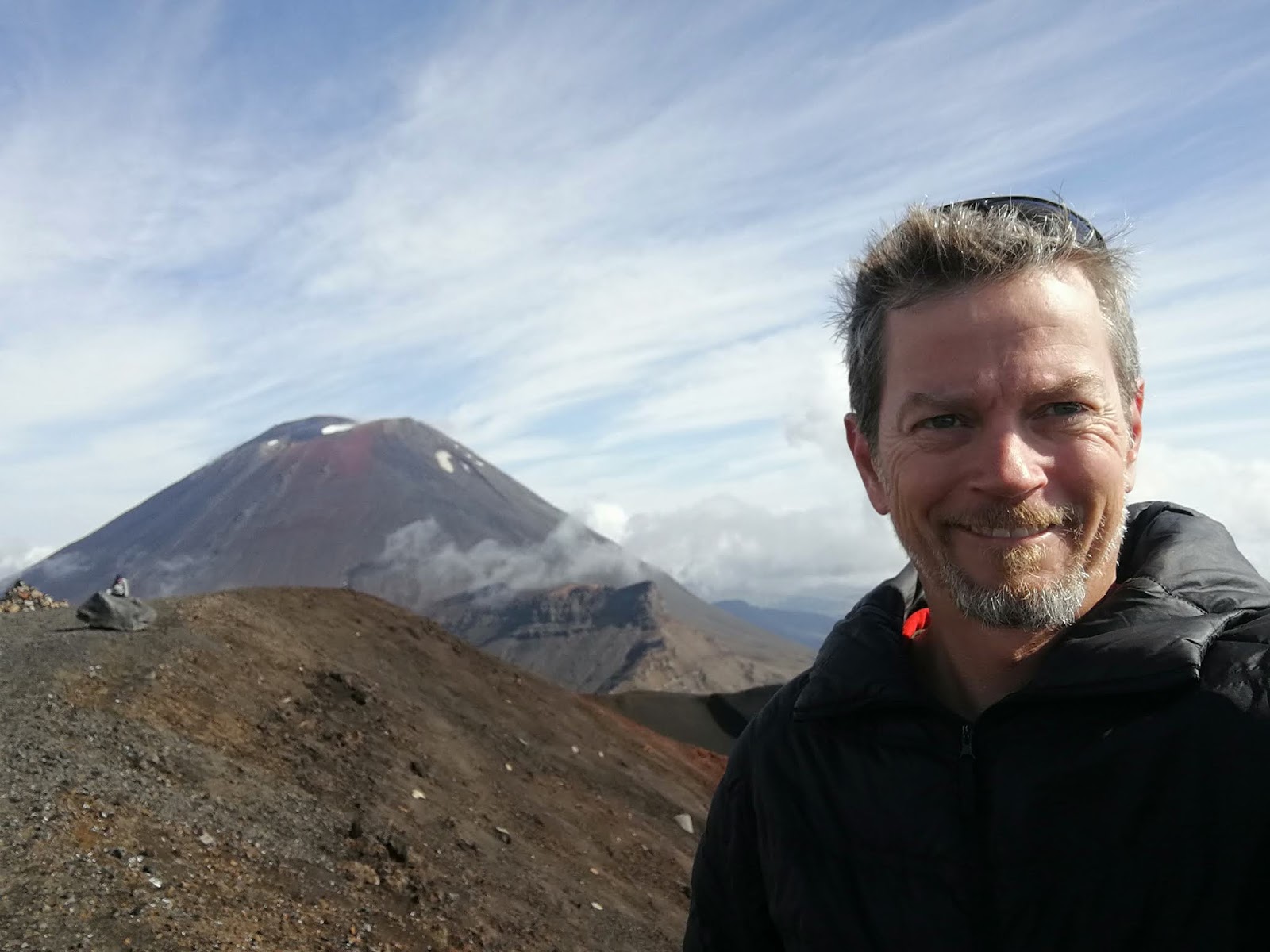
Me and the Mountain of Doom!

After about 15 minutes of being at the top of the trail, the
clouds finally parted and I got a good view of the main peak, Mount Ngauruhoe,
which was the Mountain of Doom in the Lord of the Rings. It’s a pretty stereotypical volcanic cone and
looked fantastic. Looking the other way
were great views of some different lakes below. Unfortunately, there were clouds out in the
distance covering the surrounding flat lands and it was impossible to see Mount
Taranaki, which is a few hundred kilometers away but supposedly possible to see
from here on a clear day.


Descending towards the smaller, closer lakes, the trail was
steep and the rocks were quite fine, almost like sand so people were half stepping
and half sliding down the hill. I saw
one girl fall onto her butt and I’m sure she wasn’t the only one that day. The little lakes were beautiful although I
found their colour (one being quite bright green, the other bright blue) was
lost when I removed my polarized sunglasses so the pictures don’t do them
justice.

Next it was down to another flat area, Red Crater, and then up a small climb to the biggest of the lakes, Blue Lake, which was the halfway point of the trek (distance wise). Looking back from where I’d come it was cool to see the big lava flow that had spewed part way across the crater and then stopped.

This is the view from up near the blue lake. On the right, the darker patch is newer lava.

Yay...just over half way there!

The trail curled around a bend and then it was the start of
the big descent. Although as I mentioned
earlier that the trail descended an extra 350 meters heading in this direction,
and usually most people prefer going up than going down (as it hurts the knees),
yet the trail was quite gradual. Almost
to a fault. There was one point where I
could see the next porta-pottie pitstop which didn’t look too far down the hill
but the trail snaked back and forth on super long switchbacks, so much so I
almost had to do a second illegal pee.

I didn't take a very good picture of it, but this is an impact crater from a volcanic rock from 2012. It's about 10 feet across.


As I got lower, there was a nice view of a lake with an island. The trail descended into the bush line which
was a nice change in scenery. There was
an area that had recently had a lahar sweep through it (if you don’t know what
a lahar is, look at my last post…or Google it).

The lahar slide area.


I have to admit that the last kilometre or so sure dragged
out. I reached the 19km marker and this teenage
Asian girl who was there with an American family announced the marker, but the
remaining 400 meters seemed like a long 400 meters. Finally I popped out at the end. There was a bit of a shelter with a few
tiered platforms in front of it and there were all the hikers who had already
finished, probably about 25 people, including the 2 older women I mentioned earlier.
Almost there!

I finished at 12:45 so I sat down, relaxed, and ate my
second sandwich feeling quite accomplished and waited for the first shuttle. What a hike.
The scenery was stunning, and I was pretty spent. I think that’s the longest hike I’ve done in
a day…and certainly one of the best.
I was treated to a lovely sunset to finish the day.


No comments:
Post a Comment