I stayed an extra day in Weymouth before driving up to Aldershot, to Sid and Sonia's flat. On the Sunday night before leaving I went for a hike up a nearby hill with Shirley that has the image of a big white horse, the Osmington White Horse, made from gravel on the side of it. I took my paraglider with me, hoping to maybe get a short flight...well it was short...about 2 minutes! The wind was a bit weak and in a bit off in its direction to sustain any soaring but it was my first flight in England so I was happy with it...plus my aunt got to see me fly for the first time (she still thinks I'm mad!).
We met back at the Springhead pub, had a drink and then walked home. Poor Shirley's heels were already a bit sore (I think from improperly tied shoes) that she walked part of the way home in just her socks!
Friday, October 29, 2010
Back in England
I caught the P&O ferry from Calais to Dover on a dreary morning of September 28th. I lucked out and got on an earlier ferry so I arrived back in jolly ol' England just after 9am (gained an hour in time difference). Back in BC we complain about the cost of our ferries but this route, which is about the same in length as the Victoria to Vancouver one that I have sailed on plenty of times is almost twice the cost!
I drove along the south coast of England and arrived at my aunt's place in Weymouth in the early afternoon. My cousin Sid was off work for a week and he was staying with his mom, and was often being tasked with odd jobs. The weather wasn't terribly good all week (Shirley said that it was the worst weather they'd had since I was there in April...great). However, on my birthday there was some sun between the odd rain shower and I planted 14 three feet high laurel plants on a slope in her front garden to earn my keep. Sid and I played a par 3 golf course later that afternoon and we had a lovely steak dinner and played some games.
Charles and Aunt Shirley playing Triv:

With my lovely cousin Gem:

A couple of days later, Sonia, Sid's girlfriend, trained down to join us for the weekend and we celebrated both of our birthdays again as hers was on the 25th. That evening, Charles' sister Kate and mom Leslie came over for a drink. I received some fantastic, thoughtful gifts. Two stood out. My aunt, cousins and their partners gave me a number of things but one was a custom red hoody with a white maple leaf on the front and "Underdog" on the back across the shoulders and this blog's web address at the bottom...sweet, Wandergliding is now advertising. Another gift from Kate and Leslie was a lego version of my campervan Betty...how awesome! We built it that evening and at the back of the instructions was a picture of a bunch of the lego sets from this series in a town scene. We all got a right laugh when we noticed that the lego Betty was actually getting towed!!! How apropos!
My personalized hoody:


Happy with my gift from Kate & Leslie:

Lego Betty:

It certainly was nice to spend my birthday with family...and thank you all who sent me warm birthday wishes!
Friday, October 22, 2010
Dieppe en route to Calais
Monday, September 27th
My plan today was to drive all the way to Calais as I had booked a ferry over to Dover at 9am on Tuesday morning. I got on the road mid-morning and it was a beautiful drive across Normandy with the sun shining and the odd cumulus cloud cruising across the sky.
One of many pretty French towns I drove through:

I headed towards Dieppe as I wanted to see if there was a museum or cemetery commemorating the sacrifice that many Canadians endured in a raid on Dieppe on August 19th, 1942. Dieppe is one of a few major ports on the French Atlantic coast and the Nazis had fortified the city heavily. This assault’s purpose was to test the feasibility of a full scale attack of one of the established ports in occupied France. Well, it failed quite miserably. About 6000 soldiers, all Canadian except for 275 British commandos, took part in the operation and 3367 were killed, captured or wounded...a heavy price to pay. However British Admiral Mountbatten later stated that the lessons learned that day meant that every life lost at Dieppe saved ten on D-Day.
As I entered the outskirts of the city I noticed a sign for a Canadian cemetery so I headed there first. It was a beautifully laid out graveyard with at least a few hundred soldiers buried there. I walked around reading some of the headstones and shaking my head at how young most of the men were (oh, and I did see at least one woman who was a nurse). I very much appreciate that they paid the ultimate price for our freedom today but I also couldn’t shake the thought of how horrible war is. We humans sure go out of our way to kill and hurt each other...
The Canadian cemetery at Dieppe:

On the high coast in Dieppe:

Hopping back in Betty, I set my SatNav to a Dieppe museum and after driving through town to the coast, I found out that the museum is closed and looks like it has been for a few years. Oh well, I tried.
I got back on the road and within a few hours I was in Calais. From my first day back in June, I knew where I could park for free in Betty overnight and it was close to the ferry terminal. I decided to treat myself to a dinner out...my last one in France and last one on the European continent for this phase of my travelling.
Betty and I made it back to Calais!

Tomorrow, back to England. Merci France!!!
Thursday, October 21, 2010
Juno Beach, Bunkers and more Batteries
Sunday, September 26th
I started off the day by heading to another gun battery, Longues-Sur-Mers. I was going to hit this place yesterday but I decided to delay as I wasn’t going to catch one of a handful of daily tours. Much to my dismay, when I arrived this morning for the 10:15am tour I was greeted by a temporary sign stating that there were no tours today with no reason given as to why. Oh well.
I had a walk around and there was one couple with a private tour guide so I tried to listen in a bit but the guide didn’t seem to have great information. She was mostly going on about how one mustn’t equate any war movies, Hollywood or not, to what war actually is like. Fair enough, but I would rather be learning about what we’re looking at if I’d hired her.
One of the guns had received a direct hit to its metal deflector shield. Amazing to see the thick, rusted steel peeled back like a gigantic can opener was unleashed on it.
One of the Longues-Sur-Mers guns:

Looking down the muzzle:

The hit gun:

After checking out the four gun emplacements, I wandered towards the ocean cliff to look at the observation post which was responsible for directing the artillery shells on enemy ships. It was an impressive two level concrete structure but I was amazed that the solid roof was held up by a mere four skinny metal bars...yikes. It was obvious that the post had been hit numerous times during D-Day but none of the hits made much more that a dent in the thick concrete.
The observation post:

Look at the little rods holding a hell of a lot of concrete above my head!

Nice coastline...but I wouldn't want to attack it!

Betty's younger brother, Bob, was parked next to us!

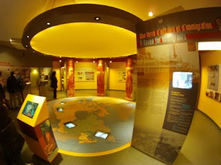
Okay, time for the next stop of the day...the Juno Beach Museum. There were five beaches that the Allies attacked on D-Day: two attacked by the Americans (Omaha & Utah), two by the Brits (Sword & Gold), and the last one was the responsibility of the Canadians, Juno Beach. Over the past few days, driving through various beachside towns, I’ve felt proud to see a number of Canadian flags flying (often along with the Union Jack and the Stars and Stripes). Now it’s time to find out a bit more detail about what the Canadian boys did here...
From the outside, the building was quite impressive, definitely in a whole different league that the ramshackle old hangar of the Omaha museum. Inside was equal in quality. It made me remember Louise (Garth’s friend in Pristina, Kosovo that I met back in August), “A museum should create a sense of mystery...leading the visitor through a variety of different multimedia experiences.” And this museum did just that. It began with a 270 degree film shown in a rectangular, slightly sloped room that was intended to make you feel as though you were on one of the landing craft...very cool. I ended up spending over 2 hours in the museum (whereas I lasted about 10 minutes in the Omaha museum). Afterwards I took a short stroll on the beach and tried to imagine what it would have been like on that morning of June 6th, 1944.
The Juno Beach Museum:

Inside the Canadian museum:
Juno Beach:

It was mid-afternoon at this point but there were still a couple more sites I hoped to see as I continued my way east along the coast. The next one was the Grand Bunker Museum. This was a reconstructed German headquarters on the same spot it stood during the war. It was disguised to look like a multilevel home but was in fact a thick concrete walled structure which directed the nearby gun batteries to protect the entrance to the river Orne.
Outside of the museum was an artillery gun, a V2 rocket and a landing craft that was actually used in D-Day and was in fact the one that Tom Hanks was filmed on for the movie of “Saving Private Ryan”. Inside the museum were five levels with various mocked up rooms and actually started with a couple of Canadian soldiers blowing up the main steel door. Canadian lieutenant Bob Orrell was sent with three other soldiers to flush out the building, the last stronghold in the area. After taking four hours to blow it open, the Germans immediately surrendered. Bob asked how many Germans were in the building and was a bit surprised to hear over 50! Not bad for four guys!
Outside the Grand Bunker:

Not my best Tom Hanks impression:

A strange German soldier in the bunker:

The lookout with the a wide, powerful range finder:

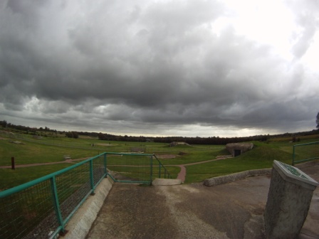
My final stop of the day was the Battery of Merville. It was a similar setup as the Longues-Sur-Mers battery I saw this morning (as you wouldn’t expect the Germans to reinvent the wheel with each new artillery emplacement), however inside the fortifications where the guns were once housed were mini-museum displays and in fact the main bunker had a simulation of what the initial attack would have been like for the Germans stationed there. It was extremely loud complete with smoke, flashing lights, German officers barking orders and shells exploding. I’m sure it still pales in comparison to what the real experience would have been like.
The Merville Battery (difficult to see but that's part of the point):

Outside they had a Dakota plane, which seemed a bit out of place seeing as it was an American workhorse that was critical in dropping paratroopers during the night before the D-Day landings. There were a few information signs talking about the plane and I was surprised to see a reference to Kosovo on one of them (having been there a month and a half ago). Turns out that this specific plane had been recovered from that region.
The Dakota:

Okay...I think I’m D-Dayed out! I continued driving along the coast and began to see what campgrounds my SatNav could find for me. I struck out the at the first few as they were closed but eventually found one which turned out to be a massive 600 site spot but there were hardly any people here at this time of the year. Fine with me. I drove into a town to get some take-out pizza as I didn’t trust that there was enough fuel in my campstove to eke out a meal. Tomorrow, off to Calais via Dieppe...only one more full day in France...
I started off the day by heading to another gun battery, Longues-Sur-Mers. I was going to hit this place yesterday but I decided to delay as I wasn’t going to catch one of a handful of daily tours. Much to my dismay, when I arrived this morning for the 10:15am tour I was greeted by a temporary sign stating that there were no tours today with no reason given as to why. Oh well.
I had a walk around and there was one couple with a private tour guide so I tried to listen in a bit but the guide didn’t seem to have great information. She was mostly going on about how one mustn’t equate any war movies, Hollywood or not, to what war actually is like. Fair enough, but I would rather be learning about what we’re looking at if I’d hired her.
One of the guns had received a direct hit to its metal deflector shield. Amazing to see the thick, rusted steel peeled back like a gigantic can opener was unleashed on it.
One of the Longues-Sur-Mers guns:

Looking down the muzzle:

The hit gun:

After checking out the four gun emplacements, I wandered towards the ocean cliff to look at the observation post which was responsible for directing the artillery shells on enemy ships. It was an impressive two level concrete structure but I was amazed that the solid roof was held up by a mere four skinny metal bars...yikes. It was obvious that the post had been hit numerous times during D-Day but none of the hits made much more that a dent in the thick concrete.
The observation post:

Look at the little rods holding a hell of a lot of concrete above my head!

Nice coastline...but I wouldn't want to attack it!

Betty's younger brother, Bob, was parked next to us!

Okay, time for the next stop of the day...the Juno Beach Museum. There were five beaches that the Allies attacked on D-Day: two attacked by the Americans (Omaha & Utah), two by the Brits (Sword & Gold), and the last one was the responsibility of the Canadians, Juno Beach. Over the past few days, driving through various beachside towns, I’ve felt proud to see a number of Canadian flags flying (often along with the Union Jack and the Stars and Stripes). Now it’s time to find out a bit more detail about what the Canadian boys did here...
From the outside, the building was quite impressive, definitely in a whole different league that the ramshackle old hangar of the Omaha museum. Inside was equal in quality. It made me remember Louise (Garth’s friend in Pristina, Kosovo that I met back in August), “A museum should create a sense of mystery...leading the visitor through a variety of different multimedia experiences.” And this museum did just that. It began with a 270 degree film shown in a rectangular, slightly sloped room that was intended to make you feel as though you were on one of the landing craft...very cool. I ended up spending over 2 hours in the museum (whereas I lasted about 10 minutes in the Omaha museum). Afterwards I took a short stroll on the beach and tried to imagine what it would have been like on that morning of June 6th, 1944.
The Juno Beach Museum:

Inside the Canadian museum:

Juno Beach:

It was mid-afternoon at this point but there were still a couple more sites I hoped to see as I continued my way east along the coast. The next one was the Grand Bunker Museum. This was a reconstructed German headquarters on the same spot it stood during the war. It was disguised to look like a multilevel home but was in fact a thick concrete walled structure which directed the nearby gun batteries to protect the entrance to the river Orne.
Outside of the museum was an artillery gun, a V2 rocket and a landing craft that was actually used in D-Day and was in fact the one that Tom Hanks was filmed on for the movie of “Saving Private Ryan”. Inside the museum were five levels with various mocked up rooms and actually started with a couple of Canadian soldiers blowing up the main steel door. Canadian lieutenant Bob Orrell was sent with three other soldiers to flush out the building, the last stronghold in the area. After taking four hours to blow it open, the Germans immediately surrendered. Bob asked how many Germans were in the building and was a bit surprised to hear over 50! Not bad for four guys!
Outside the Grand Bunker:

Not my best Tom Hanks impression:

A strange German soldier in the bunker:

The lookout with the a wide, powerful range finder:

My final stop of the day was the Battery of Merville. It was a similar setup as the Longues-Sur-Mers battery I saw this morning (as you wouldn’t expect the Germans to reinvent the wheel with each new artillery emplacement), however inside the fortifications where the guns were once housed were mini-museum displays and in fact the main bunker had a simulation of what the initial attack would have been like for the Germans stationed there. It was extremely loud complete with smoke, flashing lights, German officers barking orders and shells exploding. I’m sure it still pales in comparison to what the real experience would have been like.
The Merville Battery (difficult to see but that's part of the point):
Outside they had a Dakota plane, which seemed a bit out of place seeing as it was an American workhorse that was critical in dropping paratroopers during the night before the D-Day landings. There were a few information signs talking about the plane and I was surprised to see a reference to Kosovo on one of them (having been there a month and a half ago). Turns out that this specific plane had been recovered from that region.
The Dakota:

Okay...I think I’m D-Dayed out! I continued driving along the coast and began to see what campgrounds my SatNav could find for me. I struck out the at the first few as they were closed but eventually found one which turned out to be a massive 600 site spot but there were hardly any people here at this time of the year. Fine with me. I drove into a town to get some take-out pizza as I didn’t trust that there was enough fuel in my campstove to eke out a meal. Tomorrow, off to Calais via Dieppe...only one more full day in France...
Tuesday, October 19, 2010
Batteries, Beaches and Bad Museums
Saturday, September 25th
I walked down to the “Musee de Debarquement” (Debarkation Museum) which was located just a few hundred meters from where I was camping. This exhibit focussed on the Mulberry Harbours and had some fantastic models of these fantastic feats of engineering. To put it in perspective, it took 7 years to build the port of Dover and these guys had a functioning port in days for the light equipment and a few weeks for the big items (granted they had spent close to a year prefabricating a lot of it). Without the Mulberries, the Allies would likely have been kicked back out into the sea by the Germans.
A sunny but windy day in Arromanches:

The Allies dropped hundreds of these dummy parachutes to throw the Germans off:

Next I headed to the Maisy Gun Battery, situated about 30 kilometres to the west. At first I wasn’t sure if I was at the right place. It was hardly signposted on the road and when I turned into the empty parking lot, apart from one car, all I saw was a rusted anti-aircraft gun, a decrepit wooden landing boat and a portable trailer partly covered in a camouflage net. Hmm...not what I expected. Oh well, let’s check it out.
Hmm...is this the Maisy Battery?

There was a lonely middle aged woman sitting in the office (lonely in the sense of “bored”...). I paid my entrance fee, was given a sad looking map in a laminate cover and sent on my way. It looked like I was just walking out into a field but that in fact made sense. The Germans had tried to blend this artillery battery into the local surroundings to avoid being bombed. It was a network of trenches, bunkers, gun pads, living quarters and a command post. It was situated a couple of kilometres back from the coastline so it was connected by radio lines to an observation post by the ocean. I seemed to have the place to myself and I have to say it was a bit eerie at times to think of the German soldiers that would have occupied the bunkers that I entered and run up and down the steps that I now tread on. I was slightly startled by a strange sounding white and brown cat. It’s not often you hang out with a cat and a howitzer but here was my chance...
A howitzer:

One of a few bunkers to house soldiers:

I left the battery and headed to the Museum of the Rangers, the American Rangers. They stormed a high cliff point called Pointe du Hoc to silence some guns that could fire down on both the Utah and Omaha (the two American) beachheads. Sadly the museum was closed down so I moved on to the point instead. Arriving there I noticed three Gendarmerie cars and a few motorbikes and a very obvious special agent kinda guy (suit, dark sunglasses and the coiled earpiece). I never did find out who the VIP was but did see the large entourage pass by me as I walked out to the point.
The point has been largely left untouched from that fateful day on June 6, 1944. The shell holes created a moonlike landscape and some of the concrete bunkers where in pieces while others remained intact. There was a large group of young men in green jackets and jeans. I noticed on the badges on their left arms that they were Royal Marines. I hung out, as inconspicuously as possible, near them as their leader had some very interesting facts and insights to the events some 66 years ago. It’s incredible to think of these rangers chucking their anchored ropes up and climbing the equivalent of 6-7 storeys into a hotbed of enemy activity...hats off to you guys!
Pointe Du Hoc - notice the cratered ground:

To finish off the afternoon I stopped at a museum about Omaha Beach. This is the American beachhead that is depicted in Steven Spielberg’s “Saving Private Ryan” movie. It is in fact the beach, of the five attacked on D-Day, that suffered the most casualties (luckily all of the others incurred fewer casualties than the generals had anticipated). Well this museum was crap...and that’s my official review. It was a big steel barn with a lot of artifacts, but most of them were just bundled together in a non-contiguous set and it was just too much noise with very little explanation.
The crappy Omaha Museum:

I had read in a brochure that one of the Enigma machines was in this museum. The Enigma was a super high tech (for the day) data encoding machine that the Germans used to send encrypted messages. As a kid I remember hearing stories from my grandmother about the Enigma as the English had broke the code and were able to decode the German transmissions. However, Churchill was faced with a difficult decision at one point. He knew that Coventry, an industrial area in England, which happened to be where my grandparents with their newborn, my mother, lived, was going to be bombed by the Luffwaffe. He could have ordered the RAF to prevent the bombing but then the Germans would have realized that their transmissions were being deciphered so he held his cards close to his chest and had the difficult decision to let many innocent people die.
The Enigma machine:

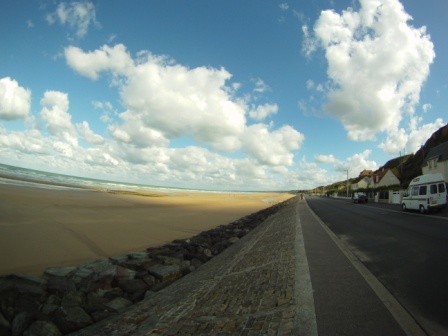
I moved on to the beach itself. It’s a gorgeous sandy expanse stretching at least 4-5 kilometers. There are a few memorials dedicated to the battle that was fought there mixed amongst houses and closed restaurants and beach shops. The wind was blowing in steadily off the water and this allowed me a chance to see one of the popular activities that are now occurring on the beach...land sailing. It seemed as though there was a race going on and these dudes were flying up and down the beach...it looked pretty cool, I will have to try that some day.
Omaha Beach (note Betty on the right!):

Looking south towards Pointe Du Hoc:

On a pier at Omaha Beach:

On my way back to Arromanches, I was surprised to see a paraglider in the air, flying above a promontory. I drove down some narrow lanes and located the launch area. The wind was too strong for solo pilots but a few tandem guys were taking up excited passengers. It was time for dinner anyways after a long day of D-Daying...with more on tap for tomorrow!
I walked down to the “Musee de Debarquement” (Debarkation Museum) which was located just a few hundred meters from where I was camping. This exhibit focussed on the Mulberry Harbours and had some fantastic models of these fantastic feats of engineering. To put it in perspective, it took 7 years to build the port of Dover and these guys had a functioning port in days for the light equipment and a few weeks for the big items (granted they had spent close to a year prefabricating a lot of it). Without the Mulberries, the Allies would likely have been kicked back out into the sea by the Germans.
A sunny but windy day in Arromanches:

The Allies dropped hundreds of these dummy parachutes to throw the Germans off:

Next I headed to the Maisy Gun Battery, situated about 30 kilometres to the west. At first I wasn’t sure if I was at the right place. It was hardly signposted on the road and when I turned into the empty parking lot, apart from one car, all I saw was a rusted anti-aircraft gun, a decrepit wooden landing boat and a portable trailer partly covered in a camouflage net. Hmm...not what I expected. Oh well, let’s check it out.
Hmm...is this the Maisy Battery?

There was a lonely middle aged woman sitting in the office (lonely in the sense of “bored”...). I paid my entrance fee, was given a sad looking map in a laminate cover and sent on my way. It looked like I was just walking out into a field but that in fact made sense. The Germans had tried to blend this artillery battery into the local surroundings to avoid being bombed. It was a network of trenches, bunkers, gun pads, living quarters and a command post. It was situated a couple of kilometres back from the coastline so it was connected by radio lines to an observation post by the ocean. I seemed to have the place to myself and I have to say it was a bit eerie at times to think of the German soldiers that would have occupied the bunkers that I entered and run up and down the steps that I now tread on. I was slightly startled by a strange sounding white and brown cat. It’s not often you hang out with a cat and a howitzer but here was my chance...
A howitzer:

One of a few bunkers to house soldiers:

I left the battery and headed to the Museum of the Rangers, the American Rangers. They stormed a high cliff point called Pointe du Hoc to silence some guns that could fire down on both the Utah and Omaha (the two American) beachheads. Sadly the museum was closed down so I moved on to the point instead. Arriving there I noticed three Gendarmerie cars and a few motorbikes and a very obvious special agent kinda guy (suit, dark sunglasses and the coiled earpiece). I never did find out who the VIP was but did see the large entourage pass by me as I walked out to the point.
The point has been largely left untouched from that fateful day on June 6, 1944. The shell holes created a moonlike landscape and some of the concrete bunkers where in pieces while others remained intact. There was a large group of young men in green jackets and jeans. I noticed on the badges on their left arms that they were Royal Marines. I hung out, as inconspicuously as possible, near them as their leader had some very interesting facts and insights to the events some 66 years ago. It’s incredible to think of these rangers chucking their anchored ropes up and climbing the equivalent of 6-7 storeys into a hotbed of enemy activity...hats off to you guys!
Pointe Du Hoc - notice the cratered ground:

To finish off the afternoon I stopped at a museum about Omaha Beach. This is the American beachhead that is depicted in Steven Spielberg’s “Saving Private Ryan” movie. It is in fact the beach, of the five attacked on D-Day, that suffered the most casualties (luckily all of the others incurred fewer casualties than the generals had anticipated). Well this museum was crap...and that’s my official review. It was a big steel barn with a lot of artifacts, but most of them were just bundled together in a non-contiguous set and it was just too much noise with very little explanation.
The crappy Omaha Museum:

I had read in a brochure that one of the Enigma machines was in this museum. The Enigma was a super high tech (for the day) data encoding machine that the Germans used to send encrypted messages. As a kid I remember hearing stories from my grandmother about the Enigma as the English had broke the code and were able to decode the German transmissions. However, Churchill was faced with a difficult decision at one point. He knew that Coventry, an industrial area in England, which happened to be where my grandparents with their newborn, my mother, lived, was going to be bombed by the Luffwaffe. He could have ordered the RAF to prevent the bombing but then the Germans would have realized that their transmissions were being deciphered so he held his cards close to his chest and had the difficult decision to let many innocent people die.
The Enigma machine:

I moved on to the beach itself. It’s a gorgeous sandy expanse stretching at least 4-5 kilometers. There are a few memorials dedicated to the battle that was fought there mixed amongst houses and closed restaurants and beach shops. The wind was blowing in steadily off the water and this allowed me a chance to see one of the popular activities that are now occurring on the beach...land sailing. It seemed as though there was a race going on and these dudes were flying up and down the beach...it looked pretty cool, I will have to try that some day.
Omaha Beach (note Betty on the right!):
Looking south towards Pointe Du Hoc:

On a pier at Omaha Beach:

On my way back to Arromanches, I was surprised to see a paraglider in the air, flying above a promontory. I drove down some narrow lanes and located the launch area. The wind was too strong for solo pilots but a few tandem guys were taking up excited passengers. It was time for dinner anyways after a long day of D-Daying...with more on tap for tomorrow!
Monday, October 18, 2010
The Tapestry of Bayeux
Friday, September 24th
I slept a generous 10 hours last night...I guess I was more tired than I realized. My quad muscles were even more unhappy with me today than yesterday from the Aiguille du Midi flight. I’m not sure which aspect did more harm to them, the slow, perilous walk down the snowy spine or the 5 kilometre walk around town (both while wearing my paragliding backpack of about 40 pounds). Probably it was the combination...
The drive up towards Caen was quite pleasant, for parts of it I was the only one on a divided highway for a number of kilometres. As I neared Caen, the skies grew incredibly dark to the north and the south...uh oh, I’m heading south about 20 km to Bayeux for two reasons. The first being that Charles, my cousin Gemma’s husband, insisted more than once that I must visit the Bayeux Tapestry. Secondly, the museum of the Battle of Normandy is located in the small, medieval like city.
The dark clouds near Bayeux:

The cathedral in Bayeux:

First up, let’s do the tapestry...can’t disappoint Charles. Plus, after that, then I can focus on D-Day themed places. Oh, I also figured I could knock the tapestry out of the way in less than an hour. I can’t say a tapestry has ever entertained me for more than five minutes before so if it can do sixty, I’ll be impressed!
The Bayeux Tapestry depicts the story of a struggle to become the King of England between William (as in William the Conqueror) and Harold Godwinson’s struggle. When King Edward the Confessor died, he had no son or heir to the throne, Harold was sent by Edward to Normandy to tell William that the throne was his however on his return and after Edward’s death, Harold assumed the throne. Upon hearing this, William amassed an army, crossed the Channel and then defeated Harold at the Battle of Hastings.
The tapestry:

And this was only one side...

Since literacy rates back some 8-900 years ago weren’t exactly stellar, it is thought that this monolithic (really mono-lengthic...it measures 68.38 meters in length!) tapestry could tell the tale to those who preferred to look at pictures (we all do a bit don’t we?!?). The tapestry, due to its age and years of mishandling, is now hermetically sealed behind glass and is housed in an old chapel but it is all darkened to help preserve this masterpiece. I received an audio guide and listened to the story as I walked along. The whole tapestry is labelled into 60 some scenes. I was surprised that at times it was tough to keep up with the audio guide and I had to pause it in order to take a moment to examine the weaving. I think it’s the first time I’ve experienced an audio guide being too fast in its narrative...usually it’s the opposite. If this tapestry were a movie, it would have to be rated R (for Restricted) due to the blatant violence. There were severed limbs and heads flying all about. One of the main characters, Harold, who was vying for the Crown of England over William, ended up with an arrow in his eye and died...I guess it wasn’t just a flesh wound!
Surprisingly the tapestry did entertain me for about an hour (caveat: that included the museum upstairs). Next I headed to the Battle of Normandy museum which was only about a kilometre away. When a lot of people think of D-Day, they only imagine the landings on the beach, which was what occurred on D-Day but this was only the first step in a long, arduous road to beating Hitler. The next phase was to consolidate the five beachheads (Omaha, Utah, Gold, Juno & Sword) and then begin to spread into the countryside...this was the Battle of Normandy. It was a fairly decent museum and I spent over 2 hours in it learning plenty. The Americans were charged with heading east and north up to Cherbourg to try and seize that port while the Canadians and Brits were heading south and then west to take the city of Caen and begin to head towards Paris. Both ran into troubles.
The Museum of the Battle of Normandy:

Inside the museum:

The Americans were slowed to a snail’s pace as they fought in terrain that heavily favoured defensive action. The “bocage” as it’s known as is a marshy area with small fields lined by hedges and often accompanied by ditches. You could easily imagine how easy it would be for surprise attacks by snipers or even just the fact that you could clear out one field and an enemy force could be hiding just 20 feet away in the next. Meanwhile the Brits and Canadians faced some stiff counterattacks by the Germans and this caused them to fall behind on their schedule of taking the city of Caen by about a month. Eventually they both broke through their stalemates and as you know, the rest is history.
I drove down to Arromanche, on the sea, to check out a possible camping site there (actually an “aire”, one of the free French rest stops). Arromanche is the site of one of the two Mulberry harbours that the Allies built. Since they had determined that attacking a deep water port directly would be too difficult and costly in lives (they learned these lessons at Dieppe on August 19th, 1942 with a mainly led Canadian raid), the Allies created a temporary type port that could be installed in a matter of days and weeks versus the usual years.
The beach at Arromanche:

After parking in the aire, I bundled up and walked down to the beach. The tide was way out, exposing a flat, compacted sand beach. The wind was howling in off the ocean with an overcast sky and the odd spray of rain. I decided to venture out towards the water which was about 400 meters out from the coastline. I shared the beach with a few hundred seagulls and that was it. A “Phoenix”, a concrete structure that the Allies used as one of the building blocks of the harbour was about midway out, on a bit of an angle. It’s probably been sitting in the same position since the day I was born. The line of the seaweed and barnacles on the side indicated that the tide raises up some 6-8 feet above the level it was at now. On the backside, facing the town, there was an open doorway starting about 5 feet above the sand. I peered in and was surprised to see a small pool with a bunch of scrambling crabs, alerted to my presence. Poor suckers...nowhere to go until the next high tide...
I returned to Betty to cook some dinner and was surprised that my fridge light was flashing. I reignited it and continued to prepare my pasta leftovers. The light flickered again...no, don’t tell me, out of camping gas again?!? I just bought that, what I thought was a half tank, from Guy 6 days ago...it can’t be out already. Oh yes it can. Thankfully I still had the little camping stove that I bought with Garth and Holly back in Slovenia so I was able to make my dinner but I think I’ll have to figure something else out for the next few days. Whenever these types of events occur, I keep reminding myself...all part of the adventure right!?!
Thursday, October 14, 2010
Travel day to the beaches of Normandy
Thursday, September 23rd
I decided to make today my travel day to head to the Normandy coast to see the D-Day landing sites. My other option was to head to Annecy for one more day of paragliding but after yesterday’s flight, I figured that was a damn good high note to finishing my European flying on.
I was on the road by about 9am and decided to take the Peage (the toll roads) for the first section of the route as it was narrow through the mountains and would have been one town after another on the alternate road. It was a nice driving day, not too hot but no rain...at least not until the evening.
As I neared Le Mans (yes, home to big time auto racing), there was a bit of a traffic jam as construction took the three lane highway down to one but then I was soon on another autoroute heading north towards Caen. The skies grew ominously grey and soon unleashed some rain. I finally pulled into an aire (a rest stop on the highway) and called it a day. It was 8pm was pleased with a 13 hour travel day and only about 100 km to get to the coast.
Flying off the Aiguille du Midi...Incroyable!!!
Wednesday, September 22nd
Conditions looked promising in the morning so after a hearty breakfast I hiked with paraglider about a kilometre to the gondola station. I first went to the mountaineering store and inquired about renting some crampons and an ice axe. I’d never actually used either but there’s always a first time for everything right?!? The guy asked me if I also needed a harness. “Ah, non, je suis toute seul.” I responded. What’s the point of having a harness if there’s no one to tie yourself to? He checked out my hiking boots and thought that they weren’t stiff enough for the task so I also rented some proper mountaineering boots.
Okay, all set. I paid my 37 Euros for a one way ride up to the top. I was a bit surprised to see that it only cost 41 for a return trip! At the midway station I transferred to the next cable car and was gobsmacked at the views of the rocky spires that rose up, reaching to the heavens. In the first few minutes at the top I could notice that my breathing and heartbeat had sped up. I was at over 11,000 feet above sea level and had gotten here in a very short time so I wasn’t surprised. Mix that in with a bit of anticipation about the narrow ridge that I knew I was going to have to traipse out on to reach the launch and it’s not too surprising my body was letting me know about its anxiety.
Going up the cable car:
There were a number of viewing platforms to check out with incredible views out over the valley, towards Mt. Blanc and north to some other impressive mountains. After a few minutes I noticed the tiny black specks...humans, climbing their way up or down from the peak of Mt. Blanc. Wow. A few were also scaling the rocky cliffs right by the gondola station. Mountaineers are a different breed that’s for sure (I’m sure a lot of you are thinking the same of us paraglider pilots!).
What views!

Mt. Blanc in the background:

Looking down at Chamonix:

The valley looked very far below:

I spent close to an hour checking out the panoramas and also looking, hoping to see another paraglider pilot so that I knew where exactly to go. I thought it was a bit funny when, on one viewing platforms, I watched 3-4 climbers come up the rocks to a ladder which climbed up to the platform and the first guy actually used one of those telescopic “put your coin in to view”, binocular stand to secure a rope around to belay a female climber coming up the ladder next. Come on, she just came up a rock face, I think she can handle a ladder!
The bridge:

On the bridge between the cable car station (on the right) and a higher lookout station:

Looking down at the cable car station from the very top:

I finally saw a couple of guys down on the snowy bowl below take off and head off over a glacier and then disappear around a corner. Okay, great, at least I know where to go. Next, I wanted to see someone walk down the razor edged snowy ridge to get to where they were. Everyone on that ridge was coming up, not going down. I thought that going down was going to be tougher than coming up.
The ridge I will walk down (the top of the shaded bit):

The plan:
It was approaching 2 o’clock and I began to be concerned that the sun was not going to be shining on the area where I was going to be launching and flying from so I decided it was time to move. I walked down the tunnelled hallway to the access point to the ridge. An awesome ice tunnel, only about 15 feet long was the entrance to the great outdoors. In this tunnel were some regular tourists, snapping their pics along with some mountaineers taking off their crampons, having just finished their adventure. Okay, time to suit up. I pulled out my crampons, and having never used them before, hoped that they would be too difficult to figure out how to put them on...perhaps I should have asked the dude in the store...
The ice cave led out to the high mountain terrain:

There was a nice 50 something German couple there and they offered to take a few photos of me before I headed out. Another younger couple was about to set out buy I could tell that the woman was quite trepidatious (see...definitely a word) about the whole affair. I decided to head out before them as it looked like she would take a long time. There was this funny little grocery store like gate with a sign saying that you were now heading out into high alpine terrain, all risk is yours (or something to that affect). I opened it up and began to step along the narrow snowy path. The first 20-30 feet were no problem, flat and easy just to put one foot in front of the other. Then the path began to descend slightly, again, not a big deal, until surprisingly when I looked to one side, I almost got a bit of vertigo from the realization that it was a steep drop off, not on one side, but both. However, if I had to choose, I was going to fall to the right as you’d only go a hundred feet or so before stopping whereas the other side, the valley side, who knows when you’d stop! Until this point, I’ve never been one to let heights throw me off and I never had a problem looking down, but here, no, keep your focus on the path Dave...look at the path...
About to hike down:

On the razor edged ridge:

Once it got to a steeper section, I wasn’t sure whether the best technique was to continue straight down or to turn around and walk down backwards. I opted for backwards and at first it seemed to be the right call but after a few minutes I wasn’t so sure. All of a sudden a couple of paraglider pilots, wearing crampons but not using an axe, came speedily towards me. I bid them hello in French and the one guy asked if I was alright. Yes, but I’m a paraglider pilot, not a mountaineer I responded in French. He told me that it was safer to go forwards down, not backwards so I decided to turn around and give it a go. I didn’t realize how much trust you could put in the crampons.
On the ridge:

This paraglider pilot pretty much raced past me...he'd obviously used crampons before. Note Chamonix down below in the valley:

Stopping for a breather part way down the ridge...heart's a racing!
The next dodgy bit came when there were climbers coming up. The first few I had let pass me by as I rested on the steep part after turning around but now I was on a slightly downhill sloping section and there was no where just to sit down. The climbers were great. Seeing as they were in groups of two or three, roped together (which equals more safety), they stepped aside and let me pass by on the trail. One mountaineer said “Lentement” (slowly) to me which I had no problem with but as I passed the next guy he moved a bit and his pack hit mine which bumped me a bit, but not enough to throw me off...and thankfully it was to my right, the not so precipitous side.
I kept my eye on the prize, the end of the narrow ridge where it turned to the right towards a big bowl. When you only step one foot slightly in front of the other, a few hundred feet can take a while! I finally made it and let out a sigh of relieve...now, let’s hope I can launch otherwise I have to go back up that ridge!
Finished the harrowing stuff...whew!

Finished the nailbiting part of the hike:
Looking back up the ridge:

The other paraglider pilots were just setting up when I arrived. I asked the one that had spoken to me earlier what he knew of this site and from what I understood it was his first flight here too. Turns out the guy, Nico, had spent some time in BC paragliding and we knew some of the same people back in Pemberton...ah, the paragliding community can be so small at times.
Someone about to take off:

One guy took off and ridge soared around the bowl for a bit before landing below and hiking back up. Nico and I were ready next and Nico had a few botched attempts in the strong wind. There was a lull so I inflated my wing and was off. Wow! I had never launched in snow before and I wished I could yell better than I can as I was ecstatic that I was in the air. I headed for a small dip in the slope to the left, the entrance to the valley with the glacier. As I cleared the gap I couldn’t believe what I was seeing...rock, glacier, mountains...incroyable!
The takeoff:
Out over the glacier:

The start of the flight:
Lovin' it:

Nico was quickly behind me but he stayed up closer to the ridge while I took a slightly more conservative route...but what exactly is conservative when you consider you are 11,000 feet above sea level, flying over a glacier surround by towering rocky mountains with technically nothing more than a bed sheet and some strings!!!
What a glacier!

Two glaciers joining together:

I cruised north, over the glacier with its greyish white fractured ice and mountains on either side. I decided to hug closer to the mountain to the west as the glacier turned in that direction and got a bit bold with flying closer to the rocks and actually passing between two spires that split near their top...spectacular! I then noticed a couple of paragliders way below me, on the other side of a glacier which was actually fed from two glaciers, the one I was over and another that runs (well, crawls) from the east). I kept my eyes on the lower guy as I questioned whether he had the height to make it out. Sometimes perception, especially in places of this kind of scale, is tough to discern but about 5 minutes later I received my answer as I watched him land on the ice...thankfully safely as I could make out his movements. Whoa...he’s got a hell of a walk out of there...could be 10 kilometres! Well, soon after I realized he might only have about 3 kms as there’s a small gondola that descends to the glacier at the end of a tourist mountain train track...still, I was happy to be me flying through the air than him on the ice!
Flying by some rocks:
Absolute thumbs up!


Enjoying the ride:
At the end of the glacier with Chamonix on the left:


About 35 minutes after launching I was over the landing zone in town with some height to practice some more wingovers. The first few I did were okay but I was still suffering from the problem of the inside edge collapsing. Then, just after completing a few, I experienced something that I don’t think I have before. One side of my paraglider slightly collapsed but quickly reinflated and it was like a wave that moved from one side of the wing all the way to the other. It was like my wing was doing the break dancing move of the worm but from the right to the left...strange.
Gliding towards Chamonix:
After landing I couldn’t help but look around at the grassy field, the trees, the Frenchmen playing Boules... I felt like I’d just arrived from another world...wow, what a flight!!!
Subscribe to:
Posts (Atom)
